-
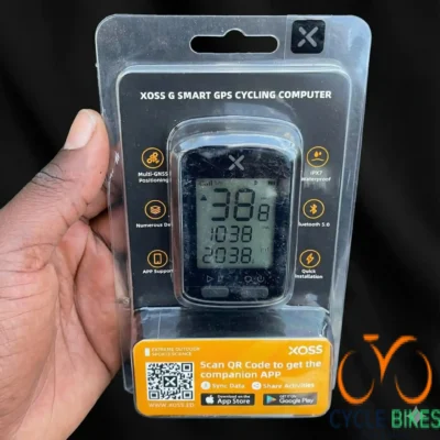
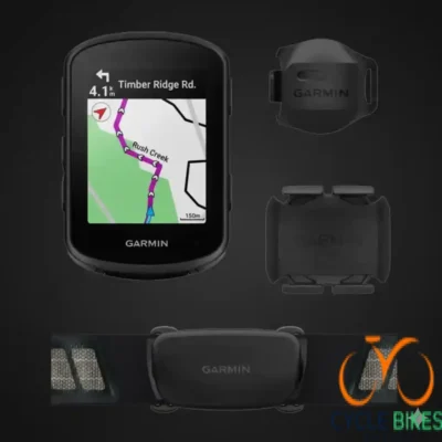
XOSS G Smart GPS Cycling Computer
-
Multi-GNSS Positioning: Utilizes integrated GPS, GLONASS, Galileo, and BeiDou satellite systems for fast and accurate location tracking anywhere in the world.
-
High-Definition LCD: Features a 1.8-inch segment LCD with an automatic backlight, ensuring all data is clear and legible in both direct sunlight and low-light conditions.
-
Essential Data Tracking: Provides real-time display of 9 key riding metrics, including current speed, ride time, distance, altitude, and total odometer.
-
IPX7 Waterproof Rating: Engineered with a rugged, water-resistant housing that can withstand heavy rain and splashes, making it reliable for all-weather riding.
-
Bluetooth 5.0 Connectivity: Seamlessly syncs your ride data to the XOSS companion app for detailed analysis and easy sharing to platforms like Strava and TrainingPeaks.
-
Long Battery Life: The built-in rechargeable lithium battery offers up to 25 hours of continuous operation on a single charge.
-
Quick & Tool-Free Installation: Includes a standard out-front mount or stem mount that allows for immediate setup on any bicycle handlebar.
KSh7,500.00XOSS G Smart GPS Cycling Computer
KSh7,500.00 -
-
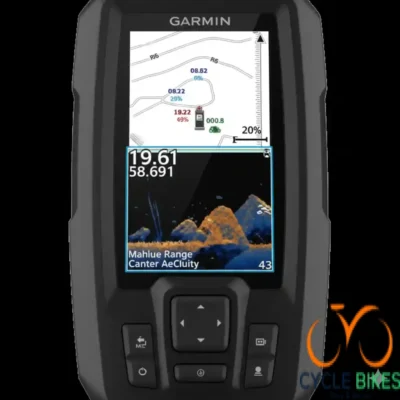
Striker Vivid 4cv,WWw/GT20
-
Vivid Scanning Sonar Colors: Choose from seven new high-contrast color palettes to see fish and structure with maximum clarity and detail.
-
GT20 Transducer Included: Comes with a GT20-TM transducer for built-in Garmin CHIRP traditional sonar and CHIRP ClearVü scanning sonar.
-
High-Sensitivity GPS: Built-in GPS allows you to mark waypoints, create routes, and view your boat’s speed for precise navigation.
-
Quickdraw Contours Mapping: Create and store personalized fishing maps with 1-foot contours for up to 2 million acres of water.
-
Rugged Hardware: Features a 4.3-inch sunlight-readable display and a durable design built to withstand the marine environment.
-
Complete Mounting Solution: Includes a tilt/swivel mount plus transom and trolling motor mounting hardware for easy installation.
KSh63,000.00Striker Vivid 4cv,WWw/GT20
KSh63,000.00 -
-
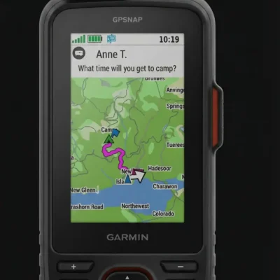
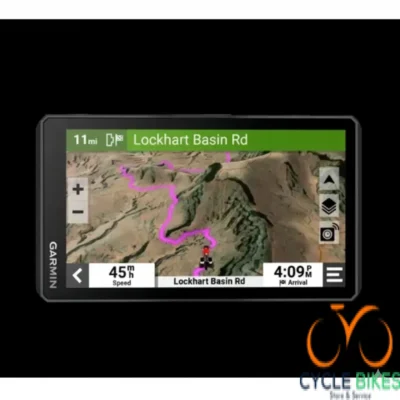
zumo XT2 MT-S, GPS, ME/Africa
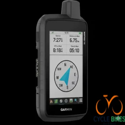
This panel focuses on real-time data:
-
Compass/Direction: Shows the current direction of travel is SE (Southeast).
-
Elevation & Heading:
-
1192ft is the current elevation.
-
154° is the current compass heading/bearing.
-
-
Speed: The current speed is 38mph.
-
Action Buttons:
-
Stop (Large orange button)
-
Split (Large white button)
-
KSh135,800.00zumo XT2 MT-S, GPS, ME/Africa
KSh135,800.00 -
-
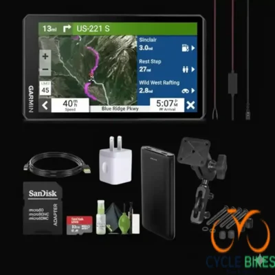
Garmin Drivesmart 76 ,MT-S,GPS
-
High-Resolution Display: Features a bright, 7-inch edge-to-edge touchscreen with 1024 x 600 pixels for easy viewing while driving.
-
Garmin Voice Assist: Enables hands-free operation, allowing you to control the device and input destinations using spoken commands.
-
Connected Smart Features: Supports Bluetooth® hands-free calling and displays smart notifications, such as text messages, directly on the screen.
-
Real-Time Live Services: Provides live traffic, weather, and fuel prices when paired with the Garmin Drive™ app on a compatible smartphone.
-
Intuitive Navigation: Includes Garmin Real Directions™ which uses recognizable landmarks and buildings for guidance, alongside Lane Assist and Junction View.
-
Regional Street Maps: Preloaded with detailed maps featuring easy software and map updates via built-in Wi-Fi®.
-
Enhanced Driver Awareness: Provides helpful alerts for upcoming speed changes, sharp curves, school zones, and environmental zones.
KSh62,000.00Garmin Drivesmart 76 ,MT-S,GPS
KSh62,000.00 -
-
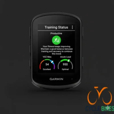
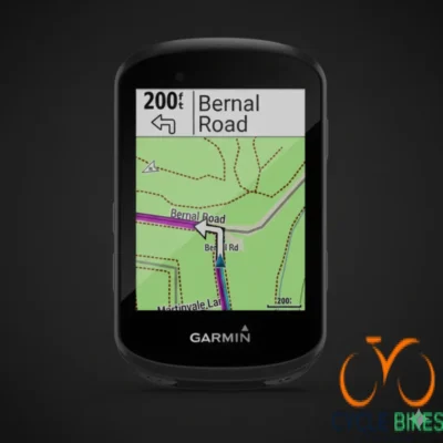
Edge 840 Bundle, ANZ/ZA
-
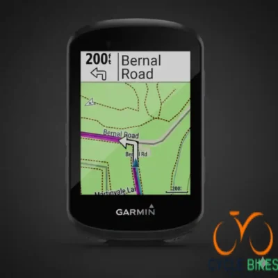
Precise Multi-Band GNSS: Utilizes multi-band GNSS technology to provide enhanced positioning accuracy even in the most challenging environments, such as dense tree cover or deep canyons.
-
Dual Interface Control: Features a responsive touchscreen alongside traditional button controls for easy navigation in any weather condition or while wearing gloves.
-
Complete Sensor Suite: This bundle includes a speed sensor, cadence sensor, and the HRM-Dual™ heart rate monitor for a comprehensive view of your training data.
-
Targeted Adaptive Coaching: Offers daily suggested workouts and training prompts directly on the device, providing personalized coaching based on your current training load and recovery.
-
ClimbPro Ascent Planner: Automatically view the remaining ascent and grade when you’re climbing while following a course, now available even on rides without a preloaded route.
-
Advanced Cycling Metrics: Monitors your Power Guide to manage your efforts throughout a course and uses Stamina insights to track how much energy you have left in the tank.
-
Long-Lasting Battery Life: Provides up to 26 hours of battery life in demanding use cases and up to 42 hours in battery saver mode.
-
Regional Mapping: Preloaded with maps tailored for the ANZ/ZA (Australia, New Zealand, and South Africa) regions, ensuring detailed turn-by-turn navigation for local trails and roads.
KSh134,798.00Edge 840 Bundle, ANZ/ZA
KSh134,798.00 -
-
Edge 530 Gps Bundle,Topoactive Africa
-
Regional Mapping: Preloaded with TopoActive Africa maps featuring routable roads, trails, and specific points of interest across the continent.
-
Performance Sensors: The bundle includes a speed sensor, cadence sensor, and a heart rate monitor for comprehensive data tracking.
-
High-Resolution Display: Equipped with a 2.6-inch sunlight-readable color display housed in a compact, aerodynamic design.
-
ClimbPro Feature: Automatically displays the remaining ascent and grade during a climb when following a route, helping you pace your effort effectively.
-
Advanced MTB Metrics: Tracks specialized mountain biking data including jump count, jump distance, hang time, and unique “Grit” and “Flow” measurements.
-
Safety & Security: Integrated with incident detection, which sends your location to emergency contacts if a crash is detected, and a pin-protected bike alarm.
-
Long-Lasting Battery: Offers up to 20 hours of life in GPS mode, extendable up to 40 hours with battery saver mode or the optional Garmin Charge power pack.
-
Superior Connectivity: Supports ANT+, Bluetooth, and Wi-Fi for seamless syncing with smartphones, sensors, and the Garmin Connect community.
KSh85,000.00Edge 530 Gps Bundle,Topoactive Africa
KSh85,000.00 -
-
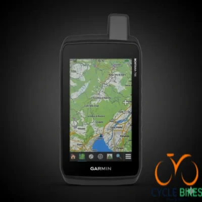
Montana 760i,AUS/NZ,TopoA ctive
-
Large Touchscreen Display: Features a sunlight-readable, 5-inch dual-orientation touchscreen that is 50% larger than previous models for enhanced map viewing.
-
Global inReach® Technology: Integrated two-way messaging and 24/7 SOS capabilities via the Iridium® satellite network (satellite subscription required).
-
Regional TopoActive Maps: Comes preloaded with routable TopoActive maps for Australia and New Zealand, providing detailed terrain and trail information.
-
Multi-GNSS Support: Accesses GPS, GLONASS, and GALILEO satellite systems for more accurate positioning in challenging environments.
-
Ruggedized Construction: Built to military standards (MIL-STD-810) for thermal, shock, vibration, and water resistance (IPX7).
-
ABC Sensor Suite: Equipped with a barometric altimeter, 3-axis electronic compass, and an accelerometer for precise environmental data.
-
Active Weather Reports: Provides real-time weather forecasts and animated weather radar when paired with a compatible smartphone.
-
Extended Battery Life: Internal rechargeable lithium-ion battery pack provides more than 18 hours in GPS mode and up to 330 hours in Expedition mode.
KSh192,000.00Montana 760i,AUS/NZ,TopoA ctive
KSh192,000.00 -
-
MONTANA 700I
-
Military Standard Durability: It is tested to MIL-STD 810 for thermal, shock, water (IPX7 water rating), and vibration resistance.
-
Long-lasting Power: The internal rechargeable lithium-ion battery provides up to 18 hours of battery life in GPS mode and up to 330 hours in ultralow-power Expedition Mode for extended trips.
-
Versatile Power: The device can also run on optional AA batteries for maximum flexibility.
-
Mount Compatibility: It is compatible with a wide variety of mounts (sold separately) for use on vehicles, ATVs, motorcycles, and boats, making it highly versatile.
KSh170,000.00MONTANA 700I
KSh170,000.00 -
-
GPSMAP 67i
-
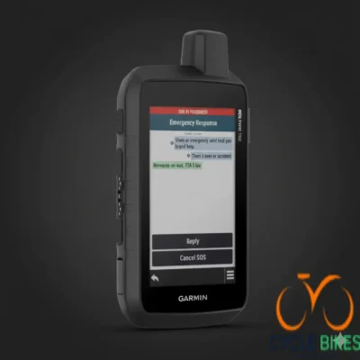
Global Satellite Communication: Features built-in inReach® technology for two-way messaging, location sharing, and 24/7 SOS triggers via the 100% global Iridium® satellite network (active subscription required).
-
Multi-Band GNSS Support: Accesses multiple global navigation satellite systems and frequencies to provide superior positioning accuracy in challenging areas like steep canyons or dense forests.
-
Expansive Map Coverage: Includes preloaded TopoActive maps and offers direct-to-device downloads of high-resolution BirdsEye Satellite Imagery without an annual subscription.
-
Premium Navigation Sensors: Equipped with a 3-axis compass and barometric altimeter to help you maintain your bearings and track elevation changes accurately.
-
Large Color Display: Features a sunlight-readable, 3-inch color display for clear viewing of maps and messages in any lighting condition.
-
Ruggedized Construction: Built to military standards (MIL-STD-810) for thermal, shock, and water performance, ensuring reliability in the harshest outdoor conditions.
-
Exceptional Battery Life: Offers up to 165 hours of battery life in 10-minute tracking mode and up to 425 hours in expedition mode, minimizing the need for frequent recharging.
KSh144,000.00GPSMAP 67i
KSh144,000.00 -
-
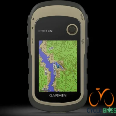
ETREX 32X- TopoActive Africa
-
High-Resolution Display: Features an enhanced 2.2″ (5.6 cm) diagonal, 65K color, sunlight-readable screen with 240 x 320 pixels for clear visibility.
-
Rugged Durability: Built to withstand the elements with a ruggedized, water-resistant housing rated to IPX7 standards.
-
Expandable Storage: Equipped with 8 GB of internal memory and a microSD™ card slot for adding additional data or map subscriptions like BirdsEye Satellite Imagery.
-
Long-Lasting Battery: Provides up to 25 hours of operation in GPS mode using just two AA batteries (NiMH or Lithium recommended).
-
Geocaching Ready: Supports paperless geocaching via GPX file uploads, allowing you to view descriptions and hints directly on the device.
-
Versatile Compatibility: Compatible with a wide range of mounts for secure use on bicycles, ATVs, boats, or during foot travel.
KSh57,000.00ETREX 32X- TopoActive Africa
KSh57,000.00 -
-
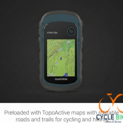
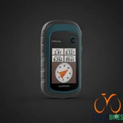
ETREX 22X
-
Preloaded Regional Mapping: Comes equipped with TopoActive maps that feature routable roads and trails specifically for cycling and hiking.
-
Sunlight-Readable Display: Features a 2.2-inch, 65K color display that remains clear and easy to read even in direct sunlight.
-
Dual-Satellite Support: Utilizes both GPS and GLONASS satellite systems to provide faster and more accurate positioning in challenging environments like deep canyons or dense forests.
-
Generous Internal Memory: Outfitted with 8 GB of internal memory for map downloads, plus a microSD™ card slot for additional storage.
-
Rugged, Water-Resistant Build: Engineered to withstand the elements with a durable design that is IPX7 water-rated.
-
Extended Battery Life: Provides up to 25 hours of operation in GPS mode using two AA batteries, making it ideal for multi-day adventures.
-
Paperless Geocaching: Supports the upload of GPX files directly to the device for viewing key information like location, terrain, and hints.
KSh50,400.00ETREX 22X
KSh50,400.00 -
-
Etrex SE,WW
-
Rugged Durability: Features a robust, water-resistant design with an IPX7 rating to withstand harsh outdoor elements.
-
Geocaching Live: Fully compatible with Geocaching Live through the Garmin Explore app for automatic cache updates and descriptions.
-
Essential Navigation: Supports Point-to-Point navigation and the TracBack® feature, which allows you to navigate back along the exact same route you traveled.
-
Internal Storage: Equipped with 28 MB of internal memory capable of storing up to 1,000 waypoints, 50 courses, and 200 activities.
-
Modern Interface: Utilizes a dedicated button and toggle joystick control system for reliable use in all conditions, featuring a modern USB-C interface for connectivity.
KSh40,000.00Etrex SE,WW
KSh40,000.00 -
-
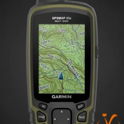
GPSMAP-65S Multi Band Africa
The GPSMAP 65s is built for high-demand navigation where precision and reliability are critical, making it an excellent tool for professional fieldwork, remote hiking, and challenging off-road expeditions in Africa.
-
Altimeter: Provides elevation data and tracks ascent/descent using barometric pressure.
-
Barometer: Used to forecast weather changes by showing short-term trends in air pressure.
-
Compass (3-Axis): A tilt-compensated electronic compass that provides an accurate heading even when standing still and not holding the device level.
KSh104,000.00GPSMAP-65S Multi Band Africa
KSh104,000.00 -
-
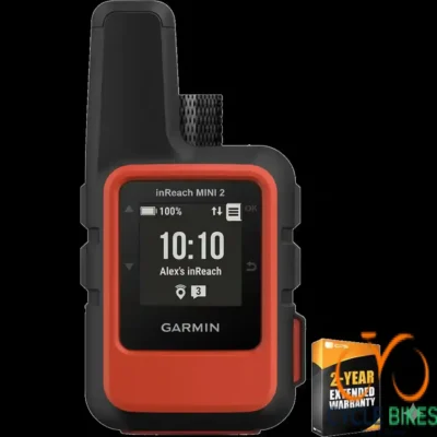
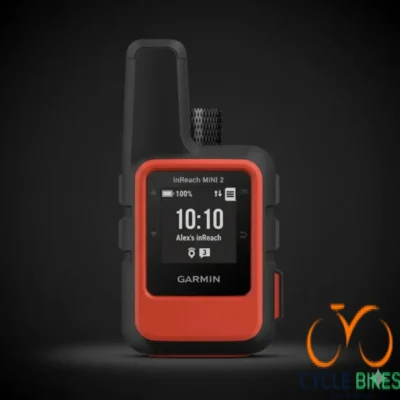
Garmin inReach Mini 2,Flame Red,GPS, EMEA
-
Color: Flame Red
-
Size & Weight: Extremely compact and lightweight: 3.9″ x 2.0″ (9.9 x 5.1 cm), 3.5 oz (100 g).
-
Durability: Rugged, impact-resistant (MIL-STD-810), and water-rated to IPX7.
-
Battery Life: Excellent endurance:
-
Up to 14 days in default 10-minute tracking mode.
-
Up to 30 days in power-saving mode (rechargeable lithium-ion battery).
-
-
Display: 0.9″ x 0.9″ sunlight-readable, monochrome transflective MIP display.
-
Connection: USB-C interface for charging and data.
-
Subscription Required: YES. An active satellite subscription (annual contract or flexible monthly plan) is mandatory to access the Iridium network for all two-way communication and SOS features.
KSh88,000.00Garmin inReach Mini 2,Flame Red,GPS, EMEA
KSh88,000.00 -
-
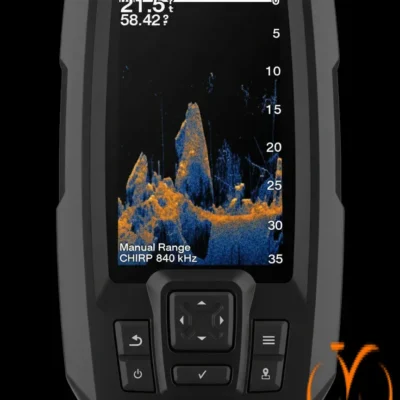
STRIKER VIVID 4CV+TRANSDUCER
-
Enhanced Visuals: Features a 4.3-inch vivid color display that makes it easier to distinguish fish from underwater structures.
-
Advanced Sonar Technology: Equipped with both CHIRP traditional sonar and CHIRP ClearVü scanning sonar for comprehensive underwater views.
-
Included Transducer: Comes with a GT20-TM transducer that delivers detailed imaging to help locate fish effectively.
-
High-Sensitivity GPS: Integrated GPS allows you to mark waypoints, create routes, and monitor your boat’s speed.
-
Custom Mapping: Includes Quickdraw Contours software, enabling you to create and store personalized maps with 1-foot contours.
KSh39,375.00STRIKER VIVID 4CV+TRANSDUCER
KSh39,375.00 -
-
zumo XT2 MT-S, GPS, ME/Africa
-
Large Ultrabright Display: Features a 6-inch high-resolution screen that is significantly brighter than previous models and easy to read in direct sunlight.
-
Rugged Construction: Built to withstand the elements with IPX7 water resistance and military-grade (MIL-STD-810) durability for drop and weather protection.
-
Advanced Mapping: Comes preloaded with topographic maps and includes access to BirdsEye Satellite Imagery to help you navigate off-road terrain.
-
Adventure Routing: Includes specialized features for both on-road and off-road navigation, allowing you to find the most scenic or challenging paths.
-
Regional Specificity: Tailored for the ME/Africa region with localized mapping and software support.
KSh84,875.00zumo XT2 MT-S, GPS, ME/Africa
KSh84,875.00 -
-
Edge 840 Bundle, ANZ/ZA
-
Dual Control Interface: Features both touchscreen and button controls for versatile operation.
-
Extended Battery Life: Offers up to 42 hours of battery life in battery saver mode.
-
Advanced Navigation: Equipped with multi-band GNSS technology and preloaded Garmin Cycle Map for accurate routing.
-
Comprehensive Training Metrics: Provides insights into stamina, VO2 max, training load, and more.
-
Ride-Specific Routing: Delivers route recommendations tailored to road, gravel, or mountain biking.
-
Safety Features: Includes incident detection, GroupTrack, and compatibility with Varia™ radar and lights.
-
Event Adaptive Coaching: Offers daily suggested workouts based on upcoming events and personal goals.
KSh84,248.75Edge 840 Bundle, ANZ/ZA
KSh84,248.75 -
-
Edge 530 Gps Bundle,Topoactive Africa
-
2.6″ Color Display: Features a high-resolution, sunlight-readable screen for clear visibility in various lighting conditions.
-
Preloaded TopoActive Africa Maps: Comes with detailed topographic maps of Africa, including roads, trails, and points of interest.
-
Performance Monitoring: Tracks VO2 max, recovery time, training load, and more to provide insights into your fitness.
-
Cycling Dynamics: Measures advanced metrics such as Grit and Flow for mountain biking, and supports Shimano Di2 electronic shifting systems.
-
Extended Battery Life: Offers up to 20 hours of battery life, extendable up to 40 hours with the optional Garmin Charge™ power pack or in battery saver mode.
-
Safety Features: Includes incident detection, bike alarm, and compatibility with Varia™ rearview radar and lights.
-
Smart Connectivity: Receives smart notifications, live tracking, and allows for group messaging when paired with a compatible smartphone
KSh53,125.00Edge 530 Gps Bundle,Topoactive Africa
KSh53,125.00 -
-
Montana 750i,GPS,TOPO
-
5″ Dual-Orientation Touchscreen: Features a high-resolution WVGA display (480 x 800 pixels) for clear visibility in various lighting conditions.
-
inReach® Satellite Communication: Offers two-way messaging and interactive SOS via the global Iridium® satellite network (active subscription required).
-
Preloaded TopoActive Maps: Comes with detailed topographic maps and City Navigator street maps (U.S. only).
-
Rugged Design: Built to military standards (MIL-STD-810) for thermal, shock, water, and vibration resistance.
-
Long Battery Life: Up to 18 hours in GPS mode and up to 330 hours in Expedition mode.
-
Wireless Connectivity: Supports Wi-Fi®, Bluetooth®, and ANT+® for seamless data sharing and app connectivity.
-
8MP Camera: Captures geotagged photos for documentation and sharing.
KSh119,998.75Montana 750i,GPS,TOPO
KSh119,998.75 -
-
MONTANA 700I
-
5″ Dual-Orientation Touchscreen: Features a high-resolution WVGA display (480 x 800 pixels) for clear visibility in various lighting conditions.
-
inReach® Satellite Communication: Offers two-way messaging and interactive SOS via the global Iridium® satellite network (active subscription required).
-
Multi-GNSS Support: Utilizes GPS and Galileo satellite systems for enhanced tracking in challenging environments.
-
Preloaded TopoActive Maps: Comes with detailed topographic maps and City Navigator street maps (U.S. only).
-
Rugged Design: Built to military standards (MIL-STD-810) for thermal, shock, water, and vibration resistance.
-
Long Battery Life: Up to 18 hours in GPS mode and up to 330 hours in Expedition mode.
-
Wireless Connectivity: Supports Wi-Fi®, Bluetooth®, and ANT+® for seamless data sharing and app connectivity
KSh106,873.75MONTANA 700I
KSh106,873.75 -
-
Etrex 32x
-
Enhanced 2.2″ Sunlight-Readable Color Display: Features a 240 x 320 pixel transflective TFT screen for clear visibility in various lighting conditions.
-
Preloaded TopoActive Maps: Comes with routable TopoActive maps, including streets and trails suitable for hiking, cycling, and off-road navigation.
-
Dual Satellite Support: Utilizes GPS and GLONASS satellite systems for improved tracking in challenging environments.
-
Additional Sensors: Equipped with a 3-axis tilt-compensated electronic compass and a barometric altimeter for accurate elevation readings.
-
Expandable Memory: Offers 8 GB of internal memory with a microSD™ card slot for additional map storage.
-
Rugged and Waterproof Design: IPX7-rated, designed to withstand harsh outdoor conditions.
-
Long Battery Life: Operates up to 25 hours on 2 AA batteries (NiMH or Lithium recommended).
-
Paperless Geocaching Support: Supports GPX file uploads for geocaching, displaying location, terrain, and hints.
-
Wireless Connectivity: Includes ANT+® support for wireless data transfer and sensor connectivity.
KSh35,625.00Etrex 32x
KSh35,625.00 -
-
ETREX 22X
-
Enhanced 2.2″ Color Display: Sunlight-readable, 65K color TFT screen (240 x 320 pixels) for clear visibility in various lighting conditions.
-
Preloaded TopoActive Maps: Includes routable roads and trails suitable for hiking, cycling, and off-road navigation.
-
Dual Satellite Support: Utilizes GPS and GLONASS satellite systems for improved tracking in challenging environments.
-
Expandable Memory: 8 GB internal memory with a microSD™ card slot for additional map storage.
-
Rugged and Waterproof: IPX7-rated, designed to withstand harsh outdoor conditions.
-
Long Battery Life: Operates up to 25 hours on 2 AA batteries (NiMH or Lithium recommended).
-
Paperless Geocaching: Supports GPX file uploads for geocaching, displaying location, terrain, and hints.
-
Compatible with BaseCamp™: Allows for trip planning and route sharing
KSh32,500.00ETREX 22X
KSh32,500.00 -
-
Etrex SE,WW
-
Multi-GNSS Support: Utilizes GPS, GLONASS, Galileo, BeiDou, and QZSS for reliable positioning.
-
Extended Battery Life: Up to 168 hours in standard mode; up to 1,800 hours in expedition mode.
-
Rugged Design: IPX7 waterproof rating; withstands immersion up to 1 meter for 30 minutes.
-
Compact Size: Dimensions of 6.1 x 10 x 3.3 cm; weighs 156.5 g with batteries.
-
Wireless Connectivity: Bluetooth® support for smart notifications and weather updates.
-
Geocaching-Friendly: Supports Geocache Live for automatic cache updates.
-
Garmin Explore™ App Compatibility: Plan trips, update software, and access additional maps
KSh25,000.00Etrex SE,WW
KSh25,000.00 -
-

GPSMAP-65S Multi Band Africa
-
Multi-Band GNSS Support: Enhanced accuracy with GPS, GLONASS, Galileo, QZSS, and IRNSS.
-
Preloaded TopoActive Africa Maps: Detailed terrain and route information across the continent.
-
2.6″ Sunlight-Readable Display: Clear visibility in various lighting conditions.
-
ABC Sensors: Built-in altimeter, barometer, and 3-axis electronic compass.
-
16-Hour Battery Life: Operates on 2 AA batteries (NiMH or Lithium recommended).
-
Rugged Design: IPX7 water rating and MIL-STD-810G compliance.
-
Smart Notifications: Receive emails, texts, and alerts when paired with a compatible device.
-
Garmin Explore™ Compatibility: Plan, review, and sync waypoints, routes, and tracks
KSh65,000.00GPSMAP-65S Multi Band Africa
KSh65,000.00 -
-
Garmin inReach Mini 2,Flame Red,GPS, EMEA
-
Compact satellite communicator with two-way messaging and SOS alerting via the Iridium® satellite network
-
Built-in GPS with TracBack® routing for navigation and backtracking
-
Up to 14 days battery life in standard mode; extended modes available
-
Weather forecasts, location sharing, and map-based trip planning via the Garmin Explore™ app
-
Rugged and waterproof design (IPX7-rated) for all-weather adventure use
-
Requires an active satellite subscription
KSh56,562.50Garmin inReach Mini 2,Flame Red,GPS, EMEA
KSh56,562.50 -